Showing posts with label cvfr. Show all posts

Friday, 27 January 2012

Best trail mapping resources. Planning offroad routes.

If you're anything like me, the best part of running is getting out in the fresh air, in the great outdoors and next to nature.

If you live in a town or any built up area, this can be hard.

For planning road routes, programs like google maps are perfectly fine, but how can you properly plan offroad routes?  How can you know which mud tracks are public footpaths and which are just made by the people who live there?  If you're not in the know, you could get into all kinds of trouble!

Today I will share a few tips on how to plan offroad routes and not get shot by farmers!

The key is using ordinance survey maps (OS maps) here in the UK as they are made in conjunction with local councils and list all the correct public rights of way.

Bikehike
www.bikehike.co.uk

This is my personal favourite.  Bikehike consists of two screens, one google satellite map, and another OS map.  The great thing is that if your mouse cursor is over the OS map, it will display its position in the google map too.  This is great for offroad paths because you can plot a route on the OS map, but it will also show up on the google map, so you can see if there is actually a physically worn path there, which makes navigation easier. 

You can also download routes you create as GPX, KML or TXC.

OS Getamap

This site is owned by Ordinance Survey and so is the most reassuredly up to date OS map available.  The reason I like this site is that you can zoom in further than any other OS map i have found whilst still keeping the public rights of way visible, and is really handy for when you need just a bit more detail to your paths.  You can create routes and download them in GPX and KML.

The Hug Maps

The functionality of this site is very similar to both bikehike and osgetamap and for route planning purposes you would do perfectly fine with them.  The reason I like this site is for its large working area.  If I am doing an ultra, or any long race, I obviously carry a map, but instead of wrestling with a full size OS landranger type monstrosity, I can plot my route on here, take a screenshot, then print it out on a more conveniently sized sheet of A4, or smaller.  The best technique is to plan your route on bikehike or osgetamap, download the file as a GPX or KML, then upload it to this site for printing.

Google Street View on Google Earth
www.earth.google.co.uk/

I use this more as a reassurance tool when it comes to planning new offroad routes.  Sometimes, even though they are clear on OS maps, entrances to footpaths can become overgrown, in tumbled town walls, or even down farmers driveways.  What I do is simply create my route in bikehike, save it is a KML and upload into into google earth.  From google earth I can then zoom into street view, and check the essential points where my route goes from offroad track to road, then find where the next track entrance is.  This is very handy and gives you a little insight into your route before you physically go there.  It is perfect for picking out gaps in walls, public footpath signs and potentially, footpaths that have been forgotten about and might not be accessible.



Saturday, 21 January 2012

White Holme Circular

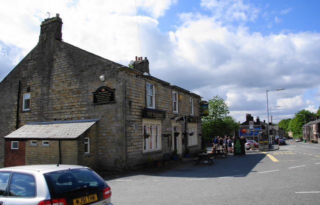
15th of January 2012. The Summit Inn

This was my first step into the world of fellrunning.  Organised by the FRA (Fell runners association) these are short, fast races of about 5-10 miles over open moorland.

The Summit Inn
The White Holme Circular was set in the beautiful west pennine area near Todmorden, notorious for its valleys that delve into the dark shadows created by the steep and unforgiving surrounding hills.

I was pleasantly suprised to find that me and my friend Jack (his first time too) were a couple of the first people there.  Seeing as we only arrived 45 minutes before the race started, it seemed it would be quite a laid back affair.

After signing on we decided to have a little warmup, up and down the road outside the race office (The Summit Inn) and the atmosphere was very friendly, with many more doing to same. Everyone was full of smiles, and greeted you with a nod and a "morning!".   Not a sniff of pretentious athletes, which was a relief from several 10ks I've done, where you just feel like the air is hostile, and people are scoping you out!  Everyone would be happy to help.  This felt more like a charity walk or a barbecue!

At around 10:30, all the competitors slowly made their way to the starting area.  Full of laughs and banter, you wouldn't think we were about to embark upon an 8 mile fell race.  Some even looked quite hungover, but I would later learn this is a fellrunners tradition!

The start
The race organiser quite casually counted us in, and off we went.  I said to myself I would just go as hard as I could and not worry about my placing, good job really!  About 30 meters from the start, the runners turned off the main track and went left up onto the first and only hill of the day.  I don't mind the odd incline, but fellrunning is quite different to road running.  This incline was steep.  From the valley floor up to the moortop, a mile and a half of uphill.  Luckily, people of all different abilities take part in these races, and walking uphill is quite common in the midpack area.  I'm sure the best run up most, but for many of us, a brisk powerwalk up the hill was enough to keep our heart rates sky high!

After the brutal first incline, things got a lot more tame.  Surrounded by the beautiful moorland, the bulk of the race consisted of flat, well beaten paths around reservoirs, the occasional muddy moorland patch, and a few hundred meters of stone slabs.

The beauty of fellrunning is, everyone suffers the same.  It doesn't matter if you're in 1st or 101st, everyone goes as hard as they can, and everyone is in the same pain.  This really becomes clear after the first few miles.

I had settled into a group of about 15 runners, all gasping for dear life like me, and it was a real challenge to keep up, and I found myself trying to beat them.  These were my competitors.  They were in my league and I would accomplish something in this race by beating them!

One of the reservoirs 
I forget how many I passed, or how many passed me.  I was quite concentrating on not dying, to be quite honest!

After a good 7 miles on the flat, the route returned to the top of the first uphill, and for the last mile and a half it would be a case of just throwing yourself downhill!  This is where serious time and places can be gained.  I threw myself down the steep hill with no regard for my own safety, trying to pass my competitors.  It felt as if my bones were going to break apart!  It seemed to go on for longer than the uphill, I was enjoying myself but I couldnt wait to get to the bottom.

Eventually, I made it to the finish line in 1 hour 27 minutes, and my Garmin actually said 9.1 miles, not the stated 8 miles.  I didnt mind, as I had set myself a target of 1 hour 20 minutes for 8 miles, so to come in just 7 minutes later having done another 1.1 miles, I was happy.

Everyone was jubilant at the finish line, and I shared tales of my grief and joy with the people hovering around the drinks table, laughing about this and that.  It was a nice atmosphere, and I hope to see these faces at the next race!

My only complaint is that the course was too flat!  I would rather have a bit of uphill, and a bit of downhill.  Not just Up, flat, and down.  I was told this was very unusual for a fell race, so I look forward to seeing the next course.

Overall I came in 72nd out of about 100.  Which I am reasonably pleased with.

Race reccomended!